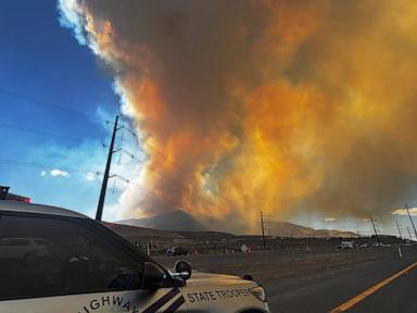
The Hawk Fire tore across more than 10,500 acres of parched foothill terrain northwest of Reno, Nevada, forcing urgent evacuation orders for thousands of residents and triggering a state emergency declaration from Governor Joe Lombardo. Sparking near the Hawk Meadow Trail and Somersett Golf and Country Club shortly before noon on a Saturday, the aggressive wildfire capitalized on high winds, single-digit relative humidity, and bone-dry cheatgrass to march northeast toward the urban interface. Zero containment was achieved in the initial operational push, setting off a scramble for shelter at overflow community centers and highlighting the brutal realities of modern Great Basin fire dynamics.
The Anatomy of an Explosive Run
Rapid expansion defines the modern fire season. When the Hawk Fire ignited near Cold Creek Trail, it measured a modest thirty acres. Within hours, wind-driven embers and extreme ambient temperatures converted a localized brush incident into a multi-thousand-acre multi-front threat.
Low humidity acts as an invisible accelerant. Vegetation across Washoe County has cured early under persistent heat, leaving behind a continuous carpet of fine fuels that carry flame lengths capable of overwhelming initial ground attacks. Gusts reaching up to forty miles per hour pushed the head of the fire relentlessly toward North Virginia Street and the western corridors of US 395, forcing incident commanders to pull heavy air resources from neighboring incidents like the nearly-contained Bug Fire.
Urban Interface Pressures
Suburban expansion along the foot of Peavine Peak places thousands of homes directly in the crosshairs of fast-moving brush fires. Neighborhoods like Somersett and Verdi feature high-density housing developments wedged tightly against volatile wildlands.
Defensible space guidelines exist on paper, but enforcement and maintenance vary wildly across private property lines. When wind-driven embers travel half a mile ahead of the main front, standard residential brush clearance often proves insufficient against localized spotting. Evacuation centers at the Evelyn Mount Northeast Community Center filled rapidly, prompting secondary staging overflows at the Reno-Sparks Convention Center as neighborhoods from Golden Valley to Lemmon Valley transitioned from warning status to mandatory flight orders.
Regional Strain and Resource Allocation
Fighting fires of this magnitude strains regional response capabilities to their absolute limit. Local agencies, including the Truckee Meadows Fire Protection District and the US Forest Service, operated under a unified command structure while simultaneously requesting immediate strike teams and dozers from Cal Fire.
Interstate coordination remains a critical bottleneck. As the fire crossed administrative boundaries and threatened Sierra County across the California line, dispatchers had to balance local structure protection in northwest Reno with perimeter control in remote timber. Logistics networks creaked under the weight of housing displaced populations, with local gaming properties stepping in to offer emergency discounted lodging rooms while animal evacuation facilities faced critical shortages due to concurrent weekend event scheduling.
The Persistent Hazard of Cheatgrass Domination
Ecological shifts dictate how violently fires behave in northern Nevada. Native perennial bunchgrasses and sagebrush have largely given way to invasive cheatgrass across the lower elevations of Peavine Peak.
Cheatgrass germinates early, matures by late spring, and creates a dense, highly flammable mat that cures weeks ahead of native flora. This cyclical invasion shortens the interval between fires from decades to mere years, preventing sagebrush ecosystems from recovering and permanently altering fire frequency. Every acre dominated by invasive annuals increases the velocity of the next ignition, turning standard summer weather events into operational crises that push emergency services past their breaking point long before autumn rain arrives.