You're standing in a Safeway parking lot in Yuba City, looking west. The Sutter Buttes are right there, jagged and weird, poking out of the flat valley floor like an afterthought. Most people think a weather forecast for Yuba City is just a carbon copy of what’s happening in Sacramento or Marysville. It isn’t. Not even close. If you’ve lived in the North Valley for more than a week, you know the wind does strange things here.
Weather in the 95991 and 95993 zip codes is a game of geography. We're tucked into the Sacramento Valley, which acts like a giant bowl. In the summer, that bowl holds heat until it feels like you're walking through soup. In the winter, it traps the "Tule Fog," a thick, white wall that makes driving down Highway 99 feel like a scene from a horror movie.
The Heat Island and the Delta Breeze Gap
Summer is when the weather forecast for Yuba City gets truly intense. We aren't just "hot." We are "I-can’t-touch-my-steering-wheel" hot. The National Weather Service in Sacramento often tracks temperatures in Yuba City that run two to four degrees higher than surrounding rural areas. This is partly due to the urban heat island effect, but mostly it's because the Delta Breeze—that cooling afternoon wind from the San Francisco Bay—often dies out before it hits the Feather River.
It’s frustrating. You see the forecast for Davis or even Roseville and they’re getting that 15 mph cool-down. Here? We get stillness.
When the temperature hits 105°F, it stays there. It lingers. According to data from the Western Regional Climate Center, Yuba City sees an average of 11 days a year where the thermometer tops 100°F, but lately, those numbers feel conservative. We’re seeing "heat domes" park themselves over the valley for a week at a time. During these stretches, the overnight lows barely drop below 70°F. Your AC isn't just a luxury; it’s the only thing keeping your house from becoming an oven.
Rain, Rice, and the Pineapple Express
Rain is a different story. When a "Pineapple Express" or an Atmospheric River (AR) aims for Northern California, Yuba City sits in a precarious spot. We rely on the levee system along the Feather and Yuba Rivers.
The weather forecast for Yuba City during the winter months (November through March) is basically a lesson in hydrology. If the snow level in the Sierra Nevada stays high—above 7,000 feet—all that precipitation falls as rain. That water rushes into the Oroville Dam and New Bullards Bar. If the Department of Water Resources has to release water quickly, our local river levels spike.
You've gotta watch the "QPF" or Quantitative Precipitation Forecast. That’s a fancy way of saying "how much rain will actually hit the dirt." If you see a forecast predicting 3+ inches of rain over 48 hours in the foothills, keep an eye on the 5th Street Bridge. The water moves fast.
Understanding the "Butte Effect"
Let’s talk about the Sutter Buttes. They call them the smallest mountain range in the world. They actually mess with our local wind patterns.
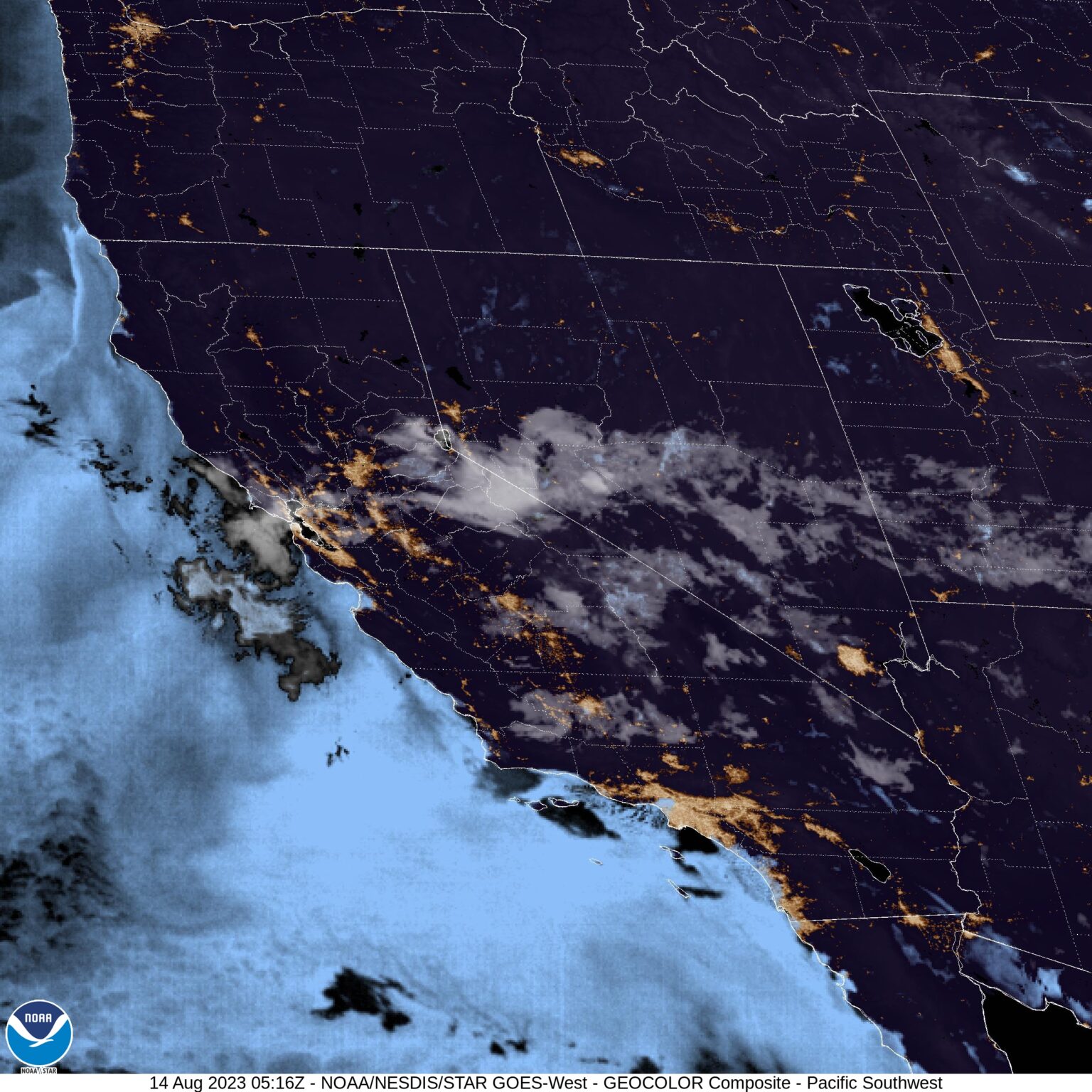
During North Wind events—those dry, gusty days that drive up fire danger in the fall—the Buttes can create a "wake." Depending on where you are in town, you might feel a howling 30 mph gust, while your cousin over in Tierra Buena has total calm. Meteorologists call this "orographic lifting" on a tiny scale. It can even cause localized rain shadows.
Sometimes, a storm cloud will look like it's headed straight for the City Council building, only to "split" around the Buttes. It’s wild to watch on radar.
The Tule Fog: Yuba City’s Winter Ghost
If you’re checking the weather forecast for Yuba City between December and February, "Patchy Fog" is the most dangerous phrase you'll read. This isn't your coastal mist. Tule Fog is unique to the Central Valley.
It forms on clear, cold nights after a rain. The ground is moist, the air is still, and a temperature inversion traps the cold air at the surface.
The visibility can drop to zero feet in seconds. One minute you’re doing 65 mph on Highway 20, and the next, you can’t see your own hood. The California Highway Patrol often has to pace traffic during these events. If the forecast mentions a "Dense Fog Advisory," believe it. It’s the leading cause of multi-car pileups in the valley. Honestly, if you don't have to be on the roads at 4:00 AM during a fog event, just stay home and have another coffee.
Real-World Prep: What the Apps Get Wrong
Your iPhone weather app is probably lying to you. Most generic apps pull data from the nearest major airport, which is often Beale Air Force Base or Sacramento International (SMF).
Beale is further east and closer to the foothills; SMF is way further south and influenced by the Delta. To get a real weather forecast for Yuba City, you need to look at local sensors.
- Check the CIMIS stations: The California Irrigation Management Information System has stations specifically in the orchards around Sutter County. This gives you the real ground-truth temperature for our agricultural microclimate.
- Look at the "Dew Point": In the summer, if the dew point stays high (above 60°F), the "swamp coolers" many older Yuba City homes use won't work. Evaporative cooling needs dry air.
- Wind Direction Matters: A wind from the South usually brings moisture and cooling. A wind from the North brings heat in the summer and bone-dry, freezing air in the winter.
Actionable Steps for Yuba City Residents
Don't just look at the high and low numbers. Weather here is about timing and preparation.
Manage the Valley Heat: If the forecast calls for 100°F+, shut your windows and blinds by 9:00 AM. In Yuba City, the sun hits the valley floor and radiates off the dry soil. By noon, the "thermal mass" of the pavement is already pushing the temp up. If you wait until it "feels hot" to close the house up, you’ve already lost the battle.
Winter Orchard Prep: If you have citrus trees in your backyard—and let’s be real, almost everyone in Yuba City has a lemon or orange tree—watch for the "Frost Advisory." When the sky is clear and the wind is dead, the heat escapes into space. Wrap your trees in burlap or keep a light on near the trunk. Don't use plastic; it traps the cold against the leaves.
River Awareness: Sign up for the CodeRED emergency alerts through Sutter County. While the 1997 floods are a distant memory for some, the levee system is a living thing. When the weather forecast for Yuba City shows a "Warm Storm" (high snow levels), the river levels are more important than the rain in your backyard.
Stay weather-aware, watch the Buttes for incoming clouds, and always keep a spare pair of windshield wipers for when the first rain hits and turns the valley dust into a muddy smear on your glass.
Monitor Local River Gauges: The most accurate way to track potential flooding during heavy rain is via the California Data Exchange Center (CDEC). Look for the "Feather River at Yuba City" gauge (station ID: YBC). This provides real-time water height levels that matter far more than a generic rain icon on a phone app.
Understand Air Quality: Because Yuba City sits in a valley "bowl," we deal with inversions. In the winter, wood smoke from fireplaces gets trapped at ground level. In the summer, wildfire smoke from the Mendocino National Forest or the Sierras settles right on top of us. Check the "AirNow.gov" site alongside your weather forecast. If the AQI (Air Quality Index) is over 150, even if it’s a beautiful 75°F day, you should probably keep the kids inside.
Prepare Your Vehicle for the North Wind: When the forecast mentions "North Winds 20-30 mph," expect debris on Highway 99. These winds are notorious for knocking down old walnut tree branches. If you're driving a high-profile vehicle like a van or a lifted truck, the crosswinds between Yuba City and Gridley can be legitimately sketchy. Keep both hands on the wheel and give the big rigs extra space.
Plan Around the "Valley Sunset": One thing the forecast won't tell you is that because we are flat, the sun feels more intense in the late afternoon. The "Golden Hour" in Yuba City is beautiful, but if you're driving West on Highway 20 toward Colusa at 5:00 PM, the sun glare is blinding. Always keep a pair of polarized sunglasses in the car; the valley haze catches the light and creates a "white-out" effect that makes seeing brake lights nearly impossible.
Timing Your Garden: The "Last Frost" date for Yuba City is typically mid-March. Even if the weather forecast for Yuba City looks balmy in February, don't be fooled. We often get a "false spring" followed by a sudden dip to 28°F that will kill your tomato starts. Wait until the soil temperature hit 60°F—usually around tax day—to really get the garden going.
By paying attention to these local quirks—the Buttes, the river levels, and the Tule fog—you’ll be way ahead of the average person just glancing at a weather app. Yuba City weather isn't just about temperature; it's about the environment we live in.