The operationalization of a temporary partition line during an asymmetric ceasefire creates a predictable zone of kinetic friction. Following the October 2025 truce between Israel and Hamas, a physical and tactical boundary known as the "yellow line" was established to demarcate the spatial distribution of forces. In theory, a ceasefire line stabilizes a conflict theater by freezing troop movements. In practice, the yellow line operates as a dynamic cost function where the price of a spatial calculation error is lethal force.
Data from the United Nations Independent International Commission of Inquiry and localized mapping analyses reveal that the enforcement of this boundary has resulted in ongoing civilian casualties, particularly children, long after the nominal cessation of major hostilities. To understand why an administrative ceasefire line produces continuous kinetic engagements, it is necessary to deconstruct the operational variables of tactical ambiguity, sensory asymmetric signaling, and the shifting geography of the buffer zone.
The Structural Mechanics of Border Ambiguity
The principal vulnerability of the yellow line lies in its physical and operational architecture. Rather than a continuous, heavily fortified barrier, the line is composed of fragmented markers: yellow concrete blocks, barrels, and earthen berms placed at irregular intervals. This creates an information asymmetry between the enforcing military force and the civilian population attempting to navigate the landscape.
Three specific structural variables convert this administrative line into a lethal zone:
- Topographical Dissolution: The destruction of urban infrastructure across the Gaza Strip has erased the traditional navigational landmarks—such as specific street intersections, distinct buildings, or municipal walls—that civilians rely on for spatial orientation. In areas like Jabalia and Khan Younis, the boundary runs through continuous fields of debris, rendering the line visually indistinguishable from the surrounding terrain.
- Asymmetric Spatial Awareness: The Israeli Defense Forces (IDF) monitor the boundary using elevated observational platforms, aerial reconnaissance, and quadcopter drones. This high-altitude perspective allows for precise digital mapping of coordinates. Conversely, a civilian on the ground possesses a zero-elevation perspective, severely limiting their ability to determine whether they are 50 meters east or west of an unmarked coordinate.
- Resource Co-location: The yellow line runs through or directly adjacent to critical survival assets. Areas designated as restricted or bordering the line contain agricultural land, standing structures containing scrap metal, and areas where dried vegetation can be gathered for firewood. This spatial overlap forces civilians to choose between economic starvation and kinetic exposure.
The Escalation Sequence: Rules of Engagement and Threat Identification
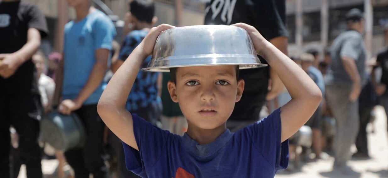
The continuous targeting of non-combatants, including the documented deaths of children such as Fadi and Juma Abu Assi while gathering firewood, stems from a systemic breakdown in the threat-identification loop. When an enforcing military operates under high-alert conditions along a ceasefire line, the operational default shifts from civilian presumption to combatant presumption.
The kinetic escalatory ladder along the yellow line follows a rigid tactical sequence that fails when applied to civilian populations:
[Visual Detection via Drone/Post]
       │
       ▼
[Classification as "Suspect"]
       │
       ▼
[Audible Warning / Warning Shots]
       │
       ▼
[Lethal Kinetic Engagement]
This sequence contains two critical points of failure. First, the classification phase relies heavily on behavioral signatures rather than positive identification. A civilian bending down to gather wood or carrying a heavy container can be misidentified by automated or remote thermal sensors as an operative planting an explosive device or transporting tactical matériel. This mechanism was demonstrated in northern Gaza where the military reported striking individuals allegedly planting explosives, while local reports identified the casualties as minors foraging near the boundary.
The second failure point occurs during the warning phase. In an active ruins landscape, the sound of warning shots can bounce off fractured concrete structures, making it impossible for a civilian to determine the direction of the fire or the intent of the shooter. If a panicked civilian runs in the wrong direction—crossing deeper into the restricted zone rather than retreating—the system interprets this behavior as evasion or hostiles advancing, triggering lethal target engagement. Medical data from hospitals like Al-Ahli and Shifa corroborate this precision, noting that many casualties present with single, highly accurate gunshot wounds consistent with sniper or directed drone fire.
Creeping Boundaries and the Expansion of the Restricted Zone
The friction along the yellow line is compounded by its geographic instability. Initial agreements in October 2025 allocated approximately 53 percent of the Gaza Strip's territory to the zone of Israeli military withdrawal or control, leaving 47 percent for Palestinian civilian movement. Satellite mapping data and field reports indicate that the line has systematically moved westward, deeper into the civilian zone. By mid-2026, the territory enclosed by the active enforcement line reached an estimated 64 percent of the Strip.
This territorial expansion operates via a mechanism known as "tactical creeping." To maximize the security depth around military outposts and lateral roads, field commanders shift physical markers forward. This creates a moving target for the local population. A geographic coordinate that was safe for civilian transit or foraging on a Tuesday can become a zero-tolerance fire zone by Thursday without any transparent mechanism of public communication.
The systemic consequence of this shifting geography is the compression of more than two million people into an increasingly narrow coastal and central strip. As the population density increases within the permitted zone, local resources are exhausted more rapidly, which in turn drives civilians to take greater physical risks near the expanding perimeter to secure basic necessities like water and fuel.
Strategic Realities of Asymmetric Ceasefire Enforcement
The operational reality of the yellow line demonstrates that an administrative truce cannot achieve kinetic stability if the boundary lines are fluid and visually ambiguous. For an enforcing force, the primary objective remains force protection; any individual crossing an arbitrary line is treated as a potential vector of asymmetric attack. For the civilian population, the lack of clear boundaries turns daily survival into a statistical game of chance.
To mitigate ongoing civilian casualties while maintaining tactical security, the enforcement model must transition away from proxy indicators and behavioral signatures. Security parameters cannot rely on shifting physical blocks that are invisible to the ground observer. Unless the boundary lines are locked into immutable, publicly verifiable geographic coordinates and enforced with non-lethal deterrents prior to kinetic engagement, the yellow line will continue to function not as a mechanism of a ceasefire, but as a continuous, low-intensity attrition zone.